 Webcam
 Weather
 Lifts
Lifts Bike Trail
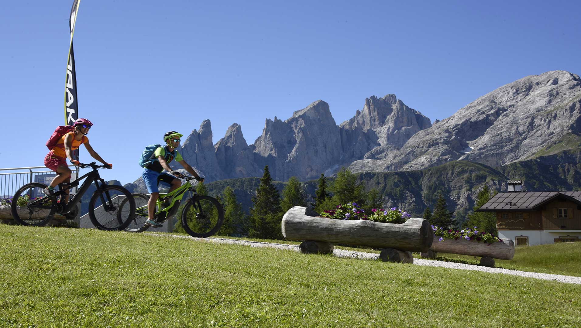
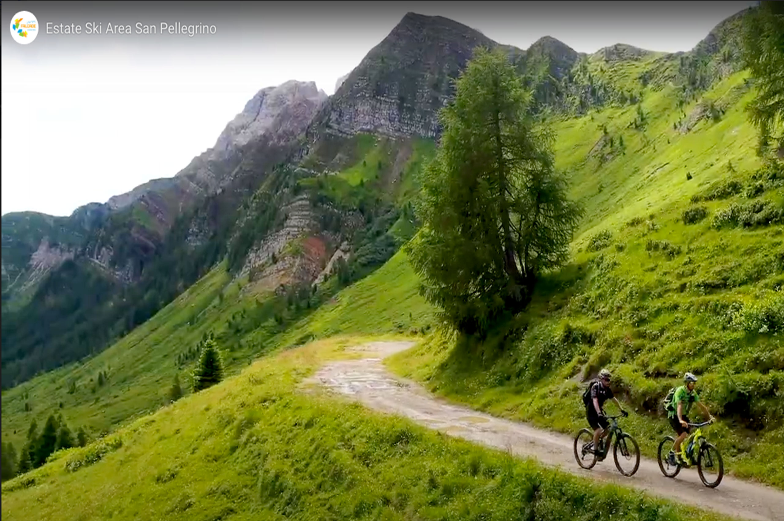
Fun and adrenaline in the new Falcade bike trail
Falcade and the Val del Biois have always been the paradise of bike lovers in all its expressions, from the quiet ride in E-BIKE among the ancient villages, discovering history, art and traditions, to the most demanding MTB routes in the Dolomites and the adrenaline-pumping descents of the exciting bike trails, dedicated to only the Braves!
The renowned Bike Friendly hospitality of Val del Biois offers a whole range of services necessary for a holiday on two wheels, from accommodation organised to accommodate bikers, to MTB and E-BIKE rental shops and equipment sales, to service and repair centres.
If you’re new to MTB, you can start by pedalling along the easy path that runs around the Falcade Plain, leading to Canale d’Agordo and on towards Cencenighe Agordino.
The more experienced, who will enjoy pedalling up in the mountains, can take the lift facilities, which are also open during the summer and carry bikes for free, choosing from the Molino-Le Buse gondola lift, the Le Buse – Laresei chairlift and the Col Margherita cableway.
Tickets for the lifts can easily and conveniently be purchased from the WEB SHOP ONLINE.
Falcade Bike Trail map
Download our map that includes elevations of the various routes
The maps with altimetry of Falcade Bike Trail can be collected at the tourist office PromoFalcade Dolomiti, located in the center of Falcade.
All the routes suggested are also suitable for electric bikes
If you’re not yet familiar with the area, or your MTB experience is limited, we recommend you enlist the help of an expert guide, consult the map and plan your trip carefully, checking the weather forecast and finding out the conditions of the route.
Falcade Bike Trail tracks
Download the gpx tracks of the routes with:
Track 1 – Piana di Falcade Le Coste
Falcade
You start from the centre of Falcade, going towards L’ Aivaz across the meadows, turn right towards Molino and once you reach the football field, cross the walkway (bridge), continue on the road until reaching Molino. Continue on the asphalt road to Falcade Alto.
At the fountain in the square, turn right, pass Somor and go up to Le Coste. Descend a short way along the asphalt road and immediately go up again on the left to Valt (mt 1302). Up to this point, you have travelled 8,600 km.
Cross the bridge over the Gavon river, descend to the right along the path to Marmolada, continue towards Sappade and just below, turn left into Via Pescosta. Descend along a path and then asphalt road to Caviola, cross the state road, leaving the playground on the right and go down to the Biois stream, cross the bridge, turn right and return to Falcade.
Download the gpx tracks of the routes with:
Track 2 – Canale d’Agordo – Gares
Val di Gares
You start from the centre of Falcade, going towards L’Aivaz across the meadows, turn left on a dirt road after about 4 km, you reach Canale D’Agordo.
After the square, leave the tourist office on the left, and at the end of the village, once you reach Soia, turn right towards Gares, pass Campion and after 3 km of gentle climb, you arrive just below the village of Gares.
Descend to the left towards Capanna Cima Comelle along a loop road passing the village of Gares (1381 metres). From here, you take the same route back.
Through the Malga Stia alternative route
From the centre of Gares, you climb to the right along a steady but steep dirt track until reaching Malga Stia, where you can recharge your E-BIKE and taste the products of the malga. You return along the same road to Gares. 6,000 Km – elevation difference 400 Mt – Time 0,50 h.
Download the gpx tracks of the routes with:
Trail 3 – Forcella S.Tomaso
San Tomaso – Vallada Agordina
You start from the centre of Falcade, going towards Valt, then continue to Sappade, where just past the church, you turn left in the direction of Jore up to Feder. Here just before the church turn left towards Rifugio Lagazzon.
Continue along the asphalt road downhill to the Vivaio Piccolet. Turn left on a dirt road towards Cogul- F.lla San Tomaso. Here you start a descent to the centre of Celat, turn left onto an asphalt road to Costa di Mezzo and left again to Pocol; at the fountain, take a very technical path on the right and after 800 metres BIKE BY HAND FOR 20 METRES OF DANGER!!
Once you reach Forchiade, turn right onto the main road, cross the bridge and in Avoscan, descend the old road to Cencenighe. Cross the town, turn right in the direction of Falcade. Leave the two tunnels on your right, and immediately after, descend the slight slope to take the dirt road that will first take you to Canale D’Agordo and then continue on the left of the stream back to Falcade.
Download the gpx tracks of the routes with:
Trail 4 – Val Venegia
Val Venegia
You start from Molino, where the cable car leaves and thanks to the two lifts (cable car and immediately after chairlift), you reach an altitude of 2203; from here, along a dirt road, you descend towards Rifugio Laresei and then up to the Valles pass.
On the right, along an asphalt road, you reach the fork for Val Vaneggia; you turn left and along the dirt road, you ride till Baita Segantini. Once over the hill, continue towards Malga Juribello along a dirt road (slight technical stretch).
You return to the fork along Passo Valles here, turn right on the asphalt road and return to Passo Valles. From here, there are two alternatives, an easy asphalt road and a picturesque but challenging path/dirt road.
Description: at the end of the square of the pass, you ride to a very technical path at the beginning, on the right up to Malga Valles Basso and then along a dirt road to Caverson, leave the Hotel Dolomiti on your left and descend the path/ski slope until you reach Molino where the lifts start.
Download the gpx tracks of the routes with:
Trail 5: Paneveggio
Paneveggio – Lusia
You start from Molino, where the cable car leaves and thanks to the two lifts (cable car + chairlift), you reach an altitude of 2203; from here, along a dirt road, you descend towards Rifugio Laresei and then ride to Passo Valles. To the right, along an asphalt road to Paneveggio just across the bridge after the Restaurant La Bicocca, turn right onto a dirt road to Passo Lusia 2056 mt.
Descend for about 2 km and just before Rifugio Rezila, turn right and climb slightly towards Malga Colvere. From here, a descent will take you to Fango 1643 mt.
Always keep to the right and climb almost to Passo S. Pellegrino along the dirt road. Along a short stretch of asphalt road and after crossing the pass, you cross the State road, and on the left, you take the road towards Ristorante Miralago, continue towards Rifugio Laresei but just before descend on the right towards Baita Flora Alpina. From here, a picturesque descent on a slightly bumpy dirt road will take you first to Somor, then to Falcade alto, along paths or state road until you reach Molino, where the lifts start.
Download the gpx tracks of the routes with:
Trail 6 – Forca Rossa tour
Forca Rossa – It’s better to make the route with MTB Guide
You start from the centre of Falcade, going towards Falcade Alto.
Cross the village and continue to Fratte, turn right on the old road that immediately becomes unpaved (WARNING IN JULY 2022 THERE ARE FALLEN TREES, possible circumvention by the State Road Passo San Pellegrino), up to the Rifugio Flora Alpina.
From here, after a short asphalt road, you turn right towards Valfreda, just above, do not take the path to the right towards Forca Rossa but go left along the high mountain grassy path. It is a very challenging stretch with bike by hand; you reach Forca Rossa 2490 m.
From here, the descent is almost extreme (recommended bike by hand) for 800 metres, and then there is a beautiful path/road that leads first to Franzedaz and then to Malga Ciapela. Continue towards Caprile and then Alleghe, along the old road until reaching Cencenighe.
Cross the town and turn right in the direction of Falcade. Leave the two tunnels on your right, and immediately after, descend the slight slope to take the dirt track that will first take you to Canale D’Agordo and then on the left of the stream will take you to Falcade.
Download the gpx tracks of the routes with:
Giro 7 – San Pellegrino Bike Trail
San Pellegrino
You start from Molino, where the cable car leaves, and thanks to the two lifts( cable car and immediately after chiarlift), you reach an altitude of 2203. From here, along a dirt road, you ride towards Rifugio Laresei and then immediately after, you turn right and climb up to Col Margherita. From here, you descend by cable car below the San Pellegrino Pass. You climb sightly along a path and descend to the Pass to take the Costabella chairlift. From here, along a dirt road, you reach the Fuciade Refuge and going around it, you continue along the path to Baita Flora Alpina. A pleasant descent along a slighty bumpy dirt road will take you first to Somor, then to the Coste, and along an asphalt road down to the Biois stream. From here, you turn right until you resch Molino anc the lift departure.
Download the gpx tracks of the routes with:
From the ancient Casoni of Valfreda, to the Gares waterfalls, a wide choice of routes of varying difficulty that wind through the woods, follow streams, reach pastures, comfortable refuges, mountain huts and refreshment points.